T.

The History Of The Two-Party Presidential Vote Mapped

Cloropleths vs Isarithmic: Voting within or without boundaries

There have been two major ways to understand populations and their territorial distribution. In one kind, typified by choropleth maps, the density or degree of a feature is mapped in pre-given political units.*
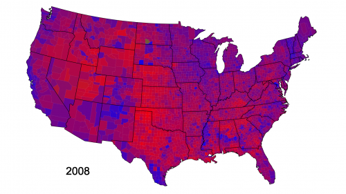
Cloropleths Map of the Presidential Vote 2008
Cloropleths Map (c) David B. Sparks

As second kind of map, known as isarithmic mapping (…), shows change varying continiously over space.*
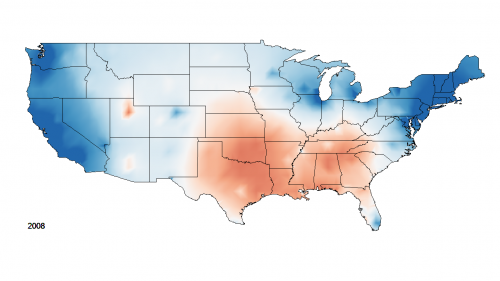
isarithmic map of the presidential vote 2008
Isarithmic mapping (c) David B. Sparks

Where chloropleths maps produce a sense of populations as contained within boundaries, isarithmic mapping emphasizes continual variation and gradual change without clear differentiations.*

References

S.

Street View becomes Street Slide

The latest fascinating contribution to Street View comes from Microsoft. With the new technology called Street Slide users do no longer teleport from one 360-degree bubble to another, but slide rather comfortably along a street panorama. The visual search has therefore become much more efficient and faster. Thanks to a mobile application, it will be much easier to find your way in the real world, using street signs and billboards both virtual and real ones.

Microsoft Research
MIT Technology Review

I.

Imaginary Landscapes and Literary Maps

Did you ever wonder which of your favorite literary characters lived in the same street or were actually neighbors? Now you can find it out.

Visit the Literary Map of Manhattan to see where some 100 imaginary New Yorkers “lived, worked, played, drank, walked and looked at ducks.” In my opinion this is the best combination of maps and literature so far.

Looking at ducks (c) www.nytimes.com

Across the Atlantic you can find a similar project called Books in London marking the location of more than 400 books either set in, or about, London.

Mapping the books. (c) www.getlondonreading.co.uk

The creators of Books in London also provide a free iPhone app of their literary map.

Augmented reality by bike.

Still another way to explore maps and literature is Gutenkarte. The so called “geographic text browser” is intended to help readers explore the spatial component of classic works of literature. Gutenkarte downloads public domain texts from Project Gutenberg, and stores all the geographic locations it can find locations in a database, along with citations into the text itself.

Tagging the world of War and Peace. (c) www.gutenkarte.org

You can also browse historical literary maps at the Library of Congress. This collection of maps was part of an exhibition entitled “Language of the Land“, a breathtaking journey through the literary heritage of the US.

The historical point of view. (c) www.loc.gov

Augmented reality is reality. And I am eager to see what is coming next.